Company
News day reporter
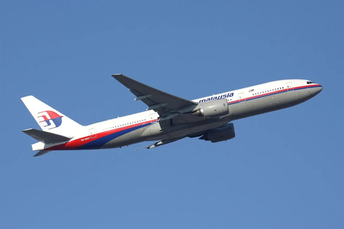
On March 8, 2014, Malaysian Airlines flight MH370, operated by a Boeing 777-200ER with 227 passengers and 12 crew on board, went missing, sending the global aviation community into panic.
Radar tracking by Malaysian Air Traffic Control (ATC) indicated the plane had deviated from its intended flight path from Kuala Lumpur to Beijing and headed southwest.
ATC lost voice communication 37 minutes after the aircraft took off, and the aircraft’s position symbol disappeared from ATC’s radar screens shortly thereafter.
Military radar tracked the plane until it was 370 km from the island of Penang in northwest Malaysia. Once the aircraft flew out of radar range, its location could not be determined, as the pilots did not provide position reports by high frequency (HF) radio as per standard operating procedures .
Subsequent analysis of satellite data and other communications data suggested that it flew southwest into the Indian Ocean. A large multinational search was launched and became the most expensive aerial search in history.
Most of the plane was never found, but some wreckage was recovered from beaches in the western Indian Ocean.
The disappearance of MH370 prompted the International Civil Aviation Organization (ICAO) to convene a meeting at its Montreal headquarters on March 12-13, 2014 to discuss global aircraft tracking.
ICAO said the disappearance of the Malaysian airliner and the crash of Air France flight AF 447 in 2009 heightened the need for improved flight tracking globally. Air France’s Rio de Janeiro-Paris flight crashed into the Atlantic on June 1, 2009, killing all 228 people on board the Airbus A330.
The meeting forged consensus among ICAO Member States and the international airline industry on the short-term priority of tracking airline flights, regardless of their location or destination in the world. At a high-level safety conference in February 2015, ICAO reaffirmed its commitment to lead a multinational initiative to develop performance-based standards for aircraft tracking. ICAO’s goal was the ability to determine the exact location of an aircraft, in real time, in any part of the world.
On April 9, 2014, Malaysia released a report recommending that ICAO consider the safety benefits of introducing a commercial aircraft real-time tracking standard.
In March 2016, ICAO adopted a new standard requiring all aircraft with a maximum certificated take-off weight greater than 27,000 kg certified on or after January 1, 2021, to autonomously transmit information to determine their position at least once per minute when in distress.
ICAO has also mandated aircraft operators to establish systems capable of tracking aircraft throughout their area of operation.

Tracking an aircraft in flight is normally performed by Secondary Surveillance Radar (SSR) and Automatic Dependent Surveillance-Broadcast (ADS-B) systems, both of which have a range of approximately 250 nautical miles. Ground stations receive position data from SSR and ADS-B aircraft and relay the information to ATC centers.
However, when aircraft fly over ocean areas beyond the range of SSR and ADS-B, the aircraft’s GPS coordinates are sent to ATC via HF or satellite radio links.
Major Air Navigation Service Providers (ANSPs) have responded to ICAO mandates and partnered with industry members such as Aireon to deliver the world’s first-ever air traffic surveillance system using an ADS network -B space that meets ICAO’s strict real-time air traffic requirements. air service surveillance (ATS) requirements for air traffic separation services anywhere in the world.
The aircraft’s onboard ADS-B system transmits its call sign, coordinates, speed, altitude and heading every half second to satellites, which relay the information to ATC facilities around the world. The system operates automatically and independently of pilot inputs.
The last known location of an aircraft is critical in search and rescue (SAR) operations because time is of the essence during an aircraft crash.
Space-based ADS-B technology bypasses the limitations of ground-based ADS-B systems, providing comprehensive, continuous monitoring of global air traffic in real time.
Previously, 70% of the world did not have access to ATC surveillance information such as oceans, polar regions, mountainous regions, jungles and deserts. ADS-B significantly improves the safety, efficiency, predictability and capacity of air traffic management, while reducing overall infrastructure costs for aviation stakeholders.
In 1950, at an ICAO meeting in Havana, Cuba, TT was given responsibility for providing air navigation services in approximately 750,000 square miles of primarily oceanic airspace, known as of Piarco flight information region.
Today, space-based ADS-B complements performance-based navigation (PBN), which is a top priority in ICAO’s global air navigation plan. PBN allows aircraft to fly more direct routes, which translates into fuel savings and reduced carbon emissions.
ABS-B systems are highly accurate and are rapidly replacing radar as the primary means of aircraft surveillance.